// SKIP TO CONTENT
NEICRONE
// NEICRONE FIELD LABS

Deployment questions, answered in the open.

The public demonstration and research layer for Physical AI evaluation. Each lab is useful to one engineering or operational decision, runs without an account, and says plainly what is live, what is synthetic, and what still needs a real site.

  1. 01 Discover
  2. 02 Configure
  3. 03 Run or inspect
  4. 04 Evaluate
  5. 05 Produce evidence
Experiment library
0205

Live labs in the Andromeda console.

Each opens the console in the state that answers its question. Filter by decision stage, or by whether the data is real.

6 of 6 labs
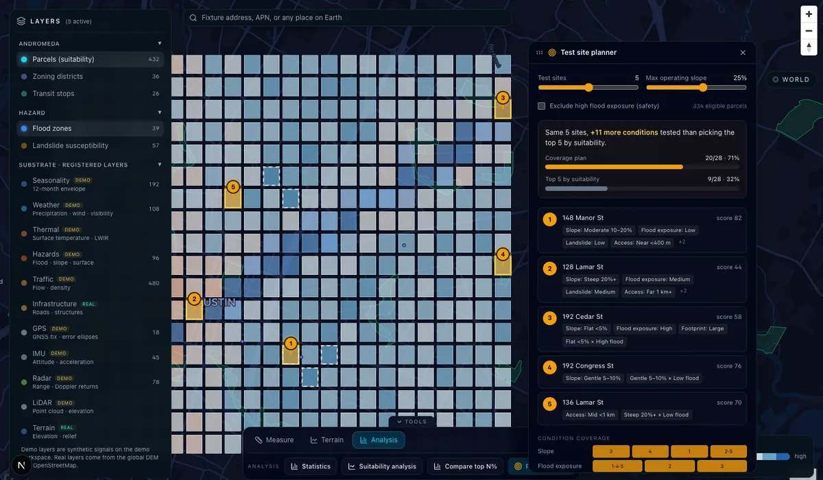
Five sites, not five copies of one site: the Andromeda consoleLAB-01 · PlanLive demo

Five sites, not five copies of one site

Q. Which few sites test the most conditions my robot will face?

The test site planner picks K sites by condition coverage inside an operating envelope, against the K most suitable sites. On the demo, 5 planned sites cover 20 of 28 conditions (71%); the top 5 by suitability cover 9 (32%).

A validation budget buys coverage, not repetition.

Real · Planning method
Real · Basemap
Synthetic · Demo parcels and their conditions
Open the planner
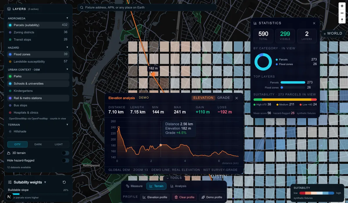
Can it climb out of the valley?: the Andromeda consoleLAB-02 · AssessLive demo

Can it climb out of the valley?

Q. What grades does a ground robot meet on this route, and where?

Elevation and grade along a 7.15 km route from the Mount Bonnell ridge to the river at downtown Austin: 241 m to 144 m, steepest −20.7%, 72% of the route under 5% grade.

Traversability is a route property, not a site property.

Real · Elevation (global DEM)
Real · Route geometry
Run the profile
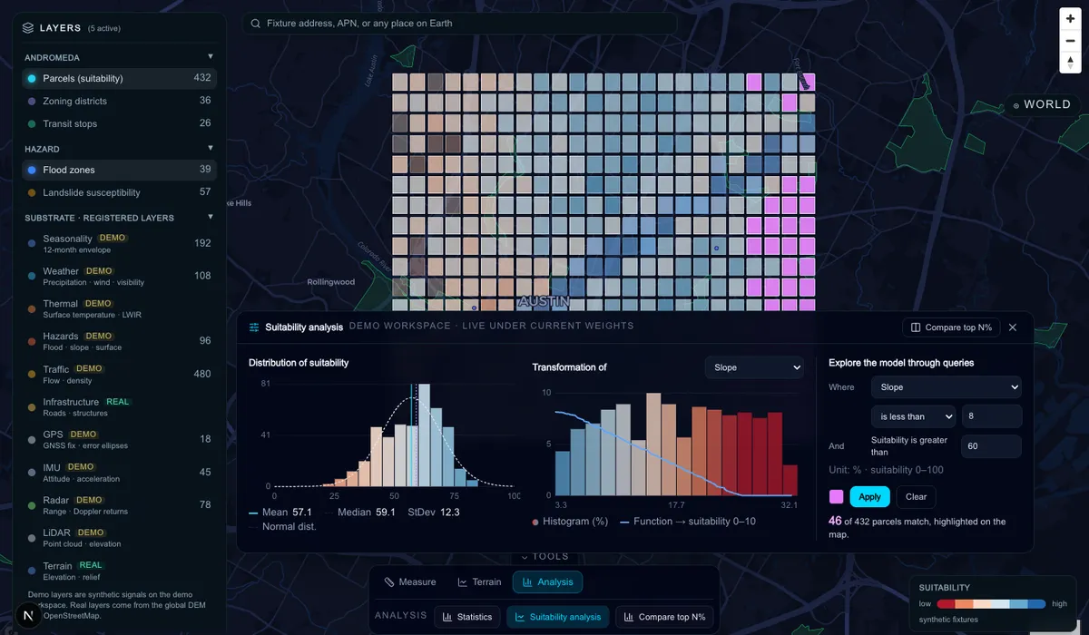
Why this site scores 81: the Andromeda consoleLAB-03 · AssessLive demo

Why this site scores 81

Q. How do the weights and raw conditions turn into a suitability score?

The score distribution under the current weights, how one criterion's raw values are transformed into suitability, and a query that highlights the parcels meeting a stated condition (slope under 8% and suitability over 60: 46 of 432).

A score is only defensible with its transformation and weights attached.

Real · Scoring model and weights
Synthetic · Demo parcels
Open the analysis
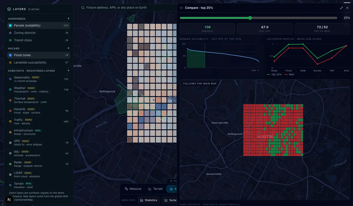
What separates the top 25%: the Andromeda consoleLAB-04 · DiscoverLive demo

What separates the top 25%

Q. What do the best candidate sites have that the rest do not?

The top N% of sites against the rest: the ranked score curve and cut-off, and a criterion profile showing which conditions drive the difference, beside a map of the classification.

A shortlist should come with the reason it is a shortlist.

Real · Scoring model
Real · Basemap
Synthetic · Demo parcels
Open the comparison
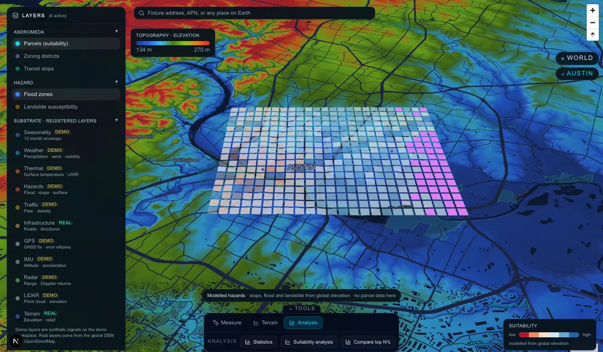
Read the ground before you go: the Andromeda consoleLAB-05 · DiscoverLive demo

Read the ground before you go

Q. Where are the ridges, valleys and drainage on a candidate site?

Colour relief in 3D, stretched over the elevations in view, anywhere on Earth: blue valleys to red ridges, with hillshade.

Terrain screening needs no local data and no site visit.

Real · Elevation (global DEM)
Real · Basemap
Open in 3D
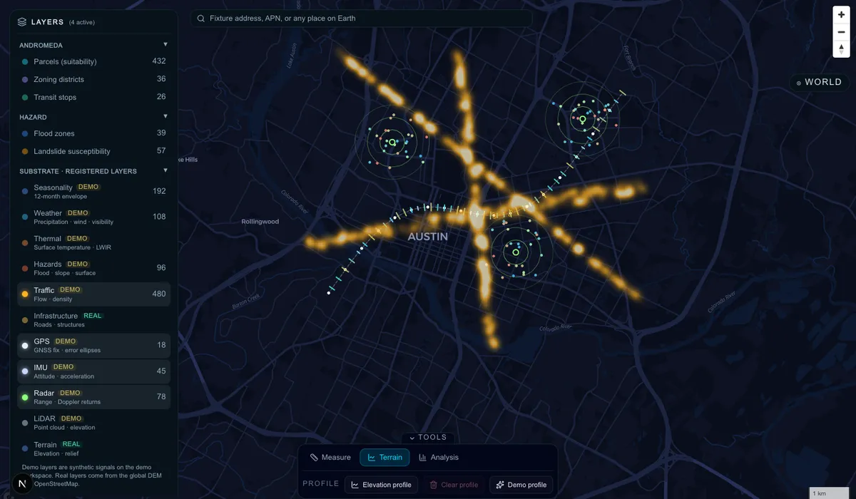
What an instrumented site records: the Andromeda consoleLAB-06 · RecordLive demo

What an instrumented site records

Q. What does the evidence layer look like once a site is instrumented?

The registered substrate channels on one site: traffic density, a logged run with GNSS error ellipses that widen in a degraded stretch, IMU acceleration ticks, and radar returns coloured by Doppler velocity.

This is the shape of the data an Evidence Record is built from.

Real · Basemap
Synthetic · All sensor channels shown
Open the substrate
Planned labs
0305

The labs that need a real site.

These answer questions only measured evidence can answer. They will appear here as validation engagements produce them, and not before.

LAB-P1PLANNED

Stop distance on wet asphalt at dusk

How does an AMR's stopping distance change on a wet surface in low light?

Needs · A robot, a yard section, and surveyed ground truth

LAB-P2PLANNED

GNSS under canopy and steel

Where does localisation degrade on a real site, and by how much?

Needs · An instrumented run with an RTK reference

LAB-P3PLANNED

Simulation vs the yard

Where does a simulated run disagree with the same run in the field?

Needs · A customer's simulation scenario and a matching field run

Field Labs roadmap
0405

Demonstrations first, then a workbench.

Each phase is built when the one before it is useful. Statuses use the same four words as the rest of the site.

Phase 1AVAILABLE

Public Field Labs

Show credible workflows and current software capability, without a physical lab.

  • Interactive demonstration galleryAVAILABLE
  • Andromeda site-intelligence labsAVAILABLE
  • Test Scenario Builder with exportable protocolsAVAILABLE
  • Evidence Record specimen generatorAVAILABLE
  • Research notes and experiment libraryAVAILABLE
Phase 2IN DEVELOPMENT

Engineering Workbench

Turn demonstrations into repeatable technical workflows.

  • Sensor and telemetry viewerIN DEVELOPMENT
  • Validation metrics and comparison toolsPLANNED
  • Versioned experiment configurationsPLANNED
  • Dataset and artifact provenancePLANNED
Phase 3LONG-TERM

Physical Validation Infrastructure

Expand only when demand, equipment, sites and measurement capability justify it.

  • Supported hardware and telemetry integrationsLONG-TERM
  • Sim-to-real comparison with reference measurementsLONG-TERM
  • Customer workspaces and controlled data accessLONG-TERM
  • Repeatable physical test campaignsLONG-TERM

Hashes and version numbers alone do not make evidence trustworthy. What matters is keeping the link between source data, processing steps, configuration and reported result, which is what the Evidence Record is designed to carry.